The Snow Water Equivalent (SWE) represents the amount of water stored as snow. Weekly SWE estimates, at the Aosta Valley level, are made using snow covered area (SCA) remotely sensed data and snow height and snow density spatial distribution. Snow spatial distribution is statistically modelled using authomatic and manual (AINEVA, Forest Guards, Army, natural parks, ...) observations of snow properties and their relation with topography and morphology (e.g. snow height increase at higher elevation).
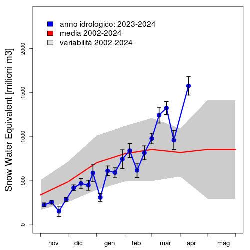

SWE and SCA seasonal evolution compared to long term mean. In both plots the red line and the grey area represent respectively the mean and the variability (2SE) of past hydrologicl years (starting from 2000). On the left, current season SWE values (milions of m3), updated to the more recent available week, are reported in blue. Black vertical bars indicate simulation uncertainty (2SE of bootstrap replicates). On the right, blue dots indicate SCA data obtained form MODIS images. SWE and SCA data are computed weekly when total regional cloud cover is below 4%.
To request available data download csv file or contact Edoardo Cremonese.
